Climb Mount Sorogan and its slopes to Mount Adi, returning via Ituroumboulou.
Low mountains, grassy peaks and intricate forests occupy the westernmost tip of the Pyrenees. Roncevale and Ilati allow for half-day hikes and long walks between the two peaks.
Access: The N-135 road from Pamplona to Roncesvalles.
Turn left one kilometer to the village of Mezquiliz and follow the paved road (4 km, first beech forest, then meadow) until you reach the village of Bordas and the Sologen Hotel.
Total time: 3 hours and 35 minutes
Altitude difference: 750 m.
Overnight stay: none.
Difficulty level: 2.
Beauty of the route: 2.
Importance of the summit: 2.
Note: There are some black spots in the beech forest on the Collado Aldatún-Aldatun Lepoa road. The descent from Iturrumba was complicated by low visibility.
We left the car near the Sorogan Hotel (860m, 0h) where we crossed a small slope and then followed a trail down to the valley floor. Then followed another trail on the left, crossing the river (no bridge) and entering the beech forest on the other side.
Right in the middle of these two paths begins a path next to the river (some markings, very confusing) which we had to follow. Soon we crossed the river and walked along one of the arms of the valley that descends from Corrado-Ardatun-Ardatun-Lepoya (northwest, left bank, overlooking Adi).
As the valley narrows, we change the river bank and begin to gain height in the beech forest. Further up, we reach a narrow spot where the two arms of the valley meet, and here we climb the rock that separates the two arms.
We will not pass through this valley again. After the spring area, we enter the area of two terraces on the right; at the turn, another steep slope begins and we emerge from the beech forest and crown the core of the cypress Collado Aldatún-Aldatun Lepoa.
On our left (0SO) we see a clear grassy slope to the left of the fence that will slowly lead us to the rocky summit of Adi, on the right, where the ascent ends after 1 hour and 45 minutes.
Back at the pass, we follow the grassy slope up the other side until we encounter a limestone ledge covered by forest.
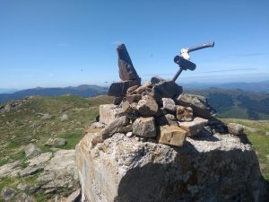
The road follows it to the left (GR marker) to reach pastures on the other side, where we can approach the obvious Iturum ledge in a flat area to the left of the divide; we follow it up (N) to the summit (Iturum, 1330m, 2h40m). Mailbox. We descend a few meters along the ascent route until we reach the scaffolding of the wire fence that appears at the foot of the summit slope. We crossed it and descended along the slope (southeast) to take advantage of the valley. At the summit of Iturunburu we saw a spring where we filled up with water and from there took the slope on its left edge as the best route to the foot of the Soroka valley, about one kilometer below the Aztakari-Aztakari-Lepoja border crossing. This path took us back to the starting point (860 meters, 3 hours and 35 minutes).